Item
·
1861
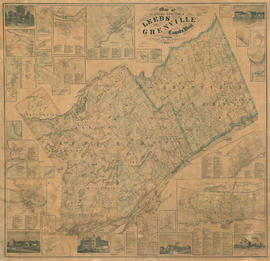
This item is a map of the United Counties of Leeds and Grenville, Canada West, as of 1861. It was based on surveys under the direction of H.F. Walling, and includes the townships of Leeds, Lansdowne, and Escott. This map includes some pictures, individual lot and concession numbers for each township, and the names of landowners (by township) in the year the map was produced.
There are insets for towns in the region, including Gananoque, Lyndhurst, Charleston and Escott. The map also includes business directories for the larger towns inset and population statistics by county for 1861.